Status (January 2026): Under Final Construction. Anticipated Opening: Late 2026.
Currently closed to the public. Do not attempt to trespass on the structure.
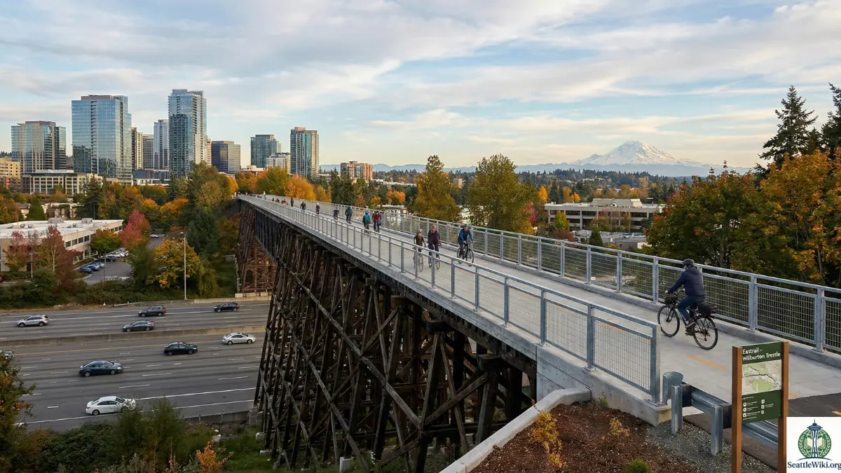
The Wilburton Trestle is the “crown jewel” of the Eastrail project. Standing 100 feet above the ground and stretching nearly 1,000 feet long, this historic railway bridge is being transformed into a pedestrian and cycling “High Line” for the Greater Seattle area. Once opened in Late 2026, it will connect the Wilburton Light Rail Station to the Mercer Slough, closing a critical gap in the regional trail network.
This guide covers the specific logistics of accessing the trestle, parking strategies, and the route map for commuters and sightseers.
Table of Contents
Quick Stats & Facts about Wilburton Trestle
| Feature | Detail |
| Total Length | 975 feet (approx. 0.2 miles) |
| Height | 102 feet (at highest point) |
| Surface Type | Paved Asphalt (18 feet wide) |
| Connections | North: Wilburton Station / NE 8th St South: Mercer Slough / I-90 Trail |
| Access Fee | Free |
| Best For | Skyline photography, commuting, flat cycling |
| Accessibility | ADA Compliant (Flat grade, paved) |
2026 Opening Timeline | Wilburton Trestle
While the structure physically exists (and has since 1904), the conversion to a safe public trail is a massive engineering project involving seismic retrofits and new decking.
- Construction Began: Summer 2024
- NE 8th Street Bridge Opened: June 2024 (Connects the station to the trail start).
- Trestle Opening: Scheduled for Late 2026.
- Note: Initial timelines estimated Summer 2026. As of early 2026, construction is in the final decking and railing phase. Check the [King County Parks Eastrail Page] for real-time delays.
Getting There: Light Rail & Transit Access
The Wilburton Trestle is unique because it is one of the few major trails in Washington designed primarily for transit access rather than car parking.
Via 2 Line (East Link Light Rail)
The easiest way to visit is via Sound Transit’s 2 Line.
- Exit Station: Get off at Wilburton Trestle Station.
- Follow Signs: Look for the “Eastrail / Regional Trail” signage on the platform.
- The Connector Bridge: Do not go down to street level at NE 8th St. Instead, take the dedicated pedestrian bridge that connects the station directly to the North side of the trail.
- Walk: It is a 5-minute walk (0.25 miles) from the station platform to the start of the Trestle.
Via Bus
- King County Metro 270 / 271: Stops at NE 8th St & 116th Ave NE.
- RapidRide B Line: Stops nearby at the Overlake Medical Center (approx. 10-minute walk).
Parking Guide (Where to Leave the Car)
There is no parking lot directly at the Wilburton Trestle. The area is dense urban infrastructure. If you must drive, use these “Trailhead” alternatives:
1. Wilburton Park & Ride (South Access)
- Location: 720 114th Ave SE, Bellevue.
- Distance: Approx. 1 mile south of the Trestle.
- Strategy: Park here, then bike or walk North along the Eastrail/Mercer Slough path. You will cross the new I-405 bridge to reach the Trestle.
2. Mercer Slough Environmental Education Center
- Location: 1625 118th Ave SE.
- Distance: 1.5 miles south.
- Strategy: Ideal for a longer nature walk. Follow the Heritage Loop Trail north to connect to the Eastrail.
3. Downtown Bellevue (North Access)
- Location: Paid garages near 116th Ave NE or Whole Foods.
- Strategy: Park at a paid lot, walk to the NE 8th Street overpass, and join the trail there. Warning: Do not park in the Whole Foods or Uwajimaya lots if you are leaving the premises; they tow aggressively.
The Route: North to South Walkthrough
If you are traversing the Wilburton Trestle, here is the sequence of landmarks you will encounter.
Segment 1: The Approach (Wilburton Station)
Starting at the NE 8th Street Bridge, you will notice large art installations. These murals honor the Japanese-American farming community that originally owned the land here before WWII internment. The path is wide, paved, and separated from the busy road below.
Segment 2: The Trestle Deck
As you step onto the wooden structure, the ground drops away.
- The View: To the West, you get a direct, unobstructed view of the Bellevue Skyline (skyscrapers like the Vulcan towers). To the South/Southeast, on a clear day, Mount Rainier frames the horizon over the I-405 traffic.
- The Experience: The new deck is concrete/asphalt on top of the wood, so it is smooth for rollerblades and road bikes. You will hear the hum of the freeway 100 feet below, but the width of the trail (18 feet) feels secure.
Segment 3: The I-405 Crossing (South End)
Immediately after the wooden trestle ends, the trail transitions onto a modern concrete bridge that crosses over the I-405 freeway. This deposits you into the Mercer Slough area, where the environment instantly changes from “Urban Industrial” to “Wetland Nature.”
Photography: Best Spots & Times
The Wilburton Trestle is expected to become the #1 Instagram spot in Bellevue in 2026.
- Sunset (Golden Hour): The sun sets behind the Bellevue skyline. Position yourself on the middle of the trestle facing West for silhouettes of the buildings against the orange sky.
- Night Shots: The freeway traffic on I-405 creates “light trails” (long exposure) running underneath the trestle. The trestle itself may have low-level safety lighting (TBD upon opening).
- Mount Rainier: Best viewed from the South end of the trestle on clear winter mornings.
Rules & Etiquette
Because this is a high-traffic commuter zone, specific “Wiki” rules apply:
- Speed Limit: 15 MPH for cyclists/e-bikes.
- Wheels vs. Heels: While not strictly painted in all sections, the general rule is Walkers Right, Bikers Left (to pass).
- Drones: Technically, launching drones from King County Parks property is often restricted or requires permits. However, flying over the trestle from private property is common. Caution: Do not fly over the active I-405 freeway; this is an FAA violation.
- Pets: Dogs must be on a leash (max 8 feet).
Amenities Nearby
Since there are no restrooms on the trestle, plan your “Bio-Breaks” accordingly.
- Restrooms:
- Wilburton Trestle Station: None (Sound Transit stations typically do not have public restrooms).
- Mercer Slough Environmental Center: Open during business hours (1.5 miles south).
- Whole Foods / Uwajimaya: North of the Trestle (customer use only).
- Food & Drink:
- The Pump House Bar & Grill: A historic local spot located almost directly under the North approach (NE 8th).
- Uwajimaya Bellevue: Massive Asian grocery store with a food court, just a 5-minute walk north of Wilburton Station.
Historical Context (Why it matters)
For the history buffs, this isn’t just a bridge.
- Built: 1904 by the Northern Pacific Railway.
- Purpose: It was part of the “Belt Line” to bypass downtown Seattle congestion.
- The “Gap”: For decades, this trestle was the missing link. Cyclists riding the “Eastrail” had to detour onto dangerous city streets to get from Kirkland to Renton. The 2026 opening finally creates a continuous “Super Highway” for bikes.
Frequently Asked Questions (FAQ)
Q: Can I walk on the Wilburton Trestle right now?
A: No. As of early 2026, it is an active construction zone. Security cameras and fences are in place. Wait for the official ribbon cutting.
Q: Is it safe for children?
A: Yes. The renovation includes high guardrails (approx. 54 inches) designed to prevent falls. The path is wide enough that children on scooters won’t accidentally veer off.
Q: Does it connect to the I-90 Trail?
A: Yes. If you head South across the trestle and continue through Mercer Slough, you will eventually hit the I-90 Trail intersection, allowing you to ride West to Seattle or East to Issaquah.
Q: Is the trestle lit at night?
A: The Eastrail generally has low-impact lighting in urban sections, but it is recommended to bring a bike light or headlamp if visiting after dusk, especially for the connecting trails which can be dark.